10 Best Places to Fly Drones in Florida

Welcome to the Sunshine State, where the skies are as inviting as the sandy beaches. Florida is a drone flyer’s paradise, offering a unique blend of breathtaking landscapes, bustling cityscapes, and serene natural reserves. In this guide to the 10 Best Places to Fly Drones in Florida, we’ll explore the top locations that showcase the state’s diverse beauty and drone-friendly environments.

From the vibrant cityscapes of Miami to the tranquil shores of Desoto Park, our blog highlights each location’s unique charm, accessibility, and airspace considerations. This ensures you have all the information you need for a safe and unforgettable drone flying experience.

So, buckle up and join us on a virtual journey to elevate your drone adventures across Florida.

10 Drone-friendly spots in Florida
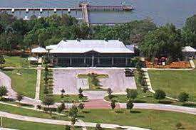
1. Desoto Park

Desoto Park is a gorgeous spot for fun and relaxation on the northern shore of McKay Bay in Tampa, Florida. The park offers a scenic walking trail that winds through vibrant greenery, providing stunning bay views.

Desoto Park Tampa - Aerial Aspectz

The main building in the park is inviting and fits right in with the natural setting. Visitors have access to a well-kept basketball court and a refreshing swimming pool, which is just the thing for a hot day.

One of the coolest parts of the park is the grass pier that stretches out into the bay, creating a peaceful and pretty place to hang out.

This pier is the perfect launchpad for drone pilots to get amazing footage of the bay’s clear blue waters. And the lively underwater world. The open spaces and the absence of tall structures in Desoto Park make it an excellent place for drone flying, offering clear skies for easy take-offs and landings.

Drone flyers can enjoy capturing the beauty of the bay and the surrounding area from a unique aerial perspective.


2. Sunset Park – St. Petersburg’s Hidden Aerial Gem

Sunset Park is a serene public park located in the heart of St. Petersburg, Florida. With its vast green space and mature trees, it offers visitors a peaceful escape from the hustle and bustle of the city.

Aerial Aspectz - St Pete Sunset Pier - Best Places to Fly Drones

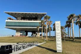
The park’s prime location provides sweeping views of Treasure Island’s sparkling waters and the stunning surrounding landscape.

The spaciousness and tranquility of Sunset Park make it an ideal place for drone hobbyists to capture stunning aerial videos and photos.

Whether you want to take in the beauty of a sunset or enjoy a leisurely drone flight, Sunset Park is an excellent choice. It’s a spot that everyone seeking a break from the noise and rush of the city should visit.


3. HICKORY POINT RECREATION PARK

Tucked away in Tavares, Florida, Hickory Point Recreation Park is a peaceful oasis on the shores of Lake Harris. This park is a dream come true for anyone looking to enjoy nature or have some outdoor fun.

Its sprawling green spaces and mature trees make it a breath of fresh air. Lake Harris, almost 14,000 acres in size, is a paradise for drone pilots. Its vast blue waters offer endless opportunities to capture stunning aerial shots.

Aerial Aspectz - HICKORY POINT RECREATION PARK - Taveres, Fl

The sandhills, wildlife areas, and towering cypress trees around the lake add to its natural beauty, making every photo or video a masterpiece.

But if you’re planning to fly your drone here, remember that the northern part of the lake is in controlled airspace. So, drone enthusiasts must be careful and follow all the rules to keep everyone safe and enjoy their flying experience.

Whether you aim to get that perfect sunset shot over the lake or just want to see the world from a new perspective. Hickory Point Recreation Park is the place to be.

It’s a must-visit for anyone looking to escape the hustle and bustle of city life and dive into the tranquility of nature.


4. RD Keene Park

Nestled in the heart of Windermere, Florida, R.D. Keene Park offers a serene escape along the shores of Lake Isleworth, just outside Orlando.

The park’s vast open spaces and mature cypress trees create a picturesque setting. Making it an ideal location for drone pilots to capture stunning aerial shots.

Aerial Aspectz - RD Keene Park - Windermere, FL

The park’s strategic location provides breathtaking views of the shimmering waters of Lake Isleworth and the surrounding area. Offering a unique visual experience for every drone flight.

With its expansive size of almost 14,000 acres, Lake Isleworth provides ample room for drone enthusiasts to elevate their photography journey. And create memorable aerial masterpieces.


5. Tangerine Field (AMA)

Are you in the mood for the excitement of remote-controlled flying? If so, check out Tangerine Field, a 50-acre paradise for aviation enthusiasts outside Orlando in Apopka.

The Remote Control Association of Central Florida and the Orlando RC Helicopter SOC Torchs manage the field, and the AMA approves it. They welcome drone pilots of all levels of experience.

You can hone your skills in wide-open areas entirely free from obstructions or connect with fellow RC pilots in sheltered buildings. And when you need a break, you can relax and refuel at the conveniently located concession area. You’re in control of the skies, and your options are limitless.

Whether you’re a seasoned pilot or a curious newcomer, Tangerine Field has something for you. It’s more than just an airfield. It’s a launchpad for unforgettable experiences and a gateway to your RC aviation journey.

6. SOUTH POINTE BEACH

South Pointe Beach, located within South Pointe Park in South Beach, Florida, is a prime spot for drone flying.

Aerial Aspectz - Top 10 Best Places to Fly Drones - South Pointe Beach

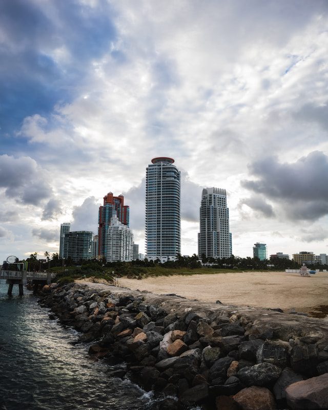
The park opened in 1985, spans 17 acres, and sits along the shore of Government Cut, where cruise ships arrive and depart to Dodge Island.

The park’s strategic location offers stunning ocean, pier, and cruise ship views, making it ideal for drone pilots. South Pointe Beach is the best spot for drone flights in Miami Beach. Because of its location at the far end of the beach, away from the crowds.

It’s not any less beautiful – you can still capture shots of the white beach, pristine blue waters, and the surrounding skyscrapers. South Pointe Beach is also an excellent spot for catching sunsets.

7. HILLSBORO INLET LIGHTHOUSE

The Hillsboro Inlet Lighthouse, built in 1907 and listed on The National Register of Historic Places, is a prominent landmark in Florida. Spanning over three acres, the lighthouse stands 136 feet tall, with a light beam range of 23 nautical miles.

Aerial Aspectz - HILLSBORO INLET LIGHTHOUSE

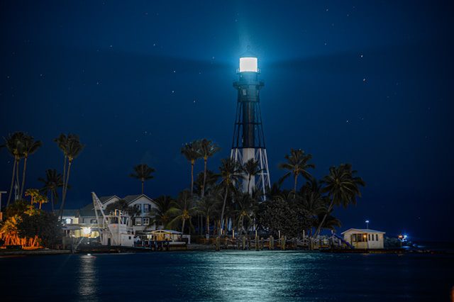
This makes it one of the most powerful in the world—the surrounding Hillsboro beach and inlet offer picturesque scenery, ideal for capturing stunning drone photos and videos.

The Hillsboro Inlet Lighthouse, a historic structure built in 1907, is a significant site listed on The National Register of Historic Places.

This towering lighthouse, standing at 136 feet tall and covering three acres, boasts a light beam range of 23 nautical miles, ranking it among the most powerful in the world. The adjacent Hillsboro beach and inlet provide a beautiful backdrop for capturing breathtaking drone photos and videos.


8. WILLIAM F. SHEFFIELD REGIONAL PARK

William F. Sheffield Regional Park, a former dairy farm site in Jacksonville, Florida, covers over 385 acres and offers various attractions. The park includes several ponds and the beautiful Lake Dumont, known for its clear, deep waters and the surrounding dense pine forest, creating a secluded atmosphere.

Drone enthusiasts will appreciate the open green areas, which make take-off and landing easier for a more enjoyable flying experience. The William F. Sheffield Regional Park in Jacksonville, Florida, was a dairy farm.

Now, it’s a huge park that’s over 385 acres. There are lots of cool things to see there. You can find some ponds and the beautiful Lake Dumont. The lake has super clear water and is surrounded by a thick pine forest. Making it feel like you’re far away from everything.

If you like flying drones, you’ll be happy to know that immense open green spaces make it easy to take off and land, so you can have a great time flying your drone there.


9. OCEANFRONT PARK

Oceanfront Park, situated in Jacksonville Beach, Florida, is a 2-acre oceanfront park with a unique circular shape surrounded by mature palm trees. The park features a wooden boardwalk leading to the beach, offering sweeping views of the Atlantic Ocean.

One of the park’s focal points is the bronze statue “Sea Express,” depicting a young boy riding a dolphin. Symbolizing the city’s commitment to preserving public access to the ocean for future generations. Oceanfront Park is ideal for drone enthusiasts to capture stunning aerial footage.

The park also offers various amenities. This includes four sheltered picnic areas, an educational kiosk system, a sand volleyball court, and a small children’s playground. These facilities make it an excellent spot for families and friends to gather and enjoy outdoor activities. And for drone pilots to capture memorable moments from above.


10. Metropolitan Park

Jacksonville’s heartbeat thrums along the St. John’s River, and nestled within its embrace lies a hidden gem. Metropolitan Park in Jacksonville, FL. This isn’t just another green space. It’s 23 acres of vibrant energy, a tapestry woven from nature, culture, and community.

Metropolitan Park’s magic goes beyond scenery. Year-round festivals burst in a riot of colors and sounds. Capture the joy of crowds dancing under the summer sun, the energy of live music, and the artistry of installations. Your drone can tell stories of human connection and cultural celebration.

The nearby marina whispers tales of adventure. Capture yachts preparing for voyages, the busy crew activity, and the serene beauty of sailboats gliding across the water. Let your drone document the spirit of exploration.

Remember to respect the park and its events, prioritizing everyone’s safety. Plan responsibly to ensure your drone captures beauty without causing disruption.

Metropolitan Park is an experience. It’s where you connect with nature, celebrate community, and capture memories with the rhythm of the river. Ready for your adventure? Grab your drone, pack your sense of wonder, and head to Metropolitan Park in Jacksonville, FL. 

Conclusion

Florida offers an incredible variety of breathtaking locations for drone enthusiasts, from serene parks and sparkling beaches to historic landmarks and vibrant cityscapes. These 10 best places to fly drones in Florida showcase the state’s diverse beauty while providing ample opportunities for creativity and exploration.

Whether you’re capturing the natural tranquility of Desoto Park, the architectural elegance of the Hillsboro Inlet Lighthouse, or the vibrant energy of Metropolitan Park, each spot offers a unique perspective from above.

At Aerial Aspectz, a drone service provider based in Orlando, FL, we’re passionate about helping drone enthusiasts and professionals make the most of their flights. For more tips, insights, or assistance, reach out to us, and let’s take your drone adventures to new heights in the Sunshine State.

7 Key Advantages of Using Drones in Solar Energy

You may be familiar with the term solar energy and its potential to revolutionize our world, but have you considered the vital role that drones can play in maximizing the efficiency of this renewable energy source? 

This post will explore 7 key advantages of using drones in solar energy, from simplified inspections to improved maintenance procedures. 

These benefits ultimately propel us toward a more sustainable future. Let’s examine the innovative ways drones shape the solar energy landscape like never before.

Here are the Top 7 Advantages of Using Drones in Solar Energy

1. Precision and Efficiency

Accurate Solar Panel Inspections

Drone technology’s efficiency has revolutionized the way we inspect solar panels. Drones with high-resolution cameras and sensors can easily detect even the most minor issues in solar panels. This accuracy is crucial for identifying hot spots, cracks, or other damages that may affect the overall efficiency of the solar system.

Time Management and Rapid Data Acquisition

Data collection with drones not only ensures precise results but also saves a significant amount of time. With drones, solar panel inspections that used to take days can now be completed in hours. The rapid acquisition of data allows for quick identification of problems, enabling prompt maintenance and maximizing energy production.

To further enhance efficiency, drones can be programmed to follow a specific flight path, ensuring that every inch of the solar panel array is thoroughly inspected. The real-time data transmitted by drones provides instant feedback to analysts, allowing them to make informed decisions swiftly.

2. Cost Reduction Strategies

Minimized Operational Expenses

Reducing operational expenses is a significant benefit of using drones for solar energy applications. Drones can efficiently conduct inspections and maintenance tasks, reducing the need for manual labor and lengthy downtime. By utilizing drones, companies can save on costs associated with traditional solar panel monitoring and upkeep methods.

Enhanced Safety and Reduced Insurance Costs

Operational safety is paramount in the solar energy industry, and drones are vital in enhancing safety measures and reducing insurance costs. Drones can reach high-risk areas without endangering human lives, minimizing the chances of accidents and injuries. This increased safety record can lead to lower insurance premiums for solar companies, resulting in substantial cost savings in the long run.

Minimized risk of accidents and injuries by using drones for inspections and maintenance tasks can significantly reduce insurance premiums for solar companies. This enhanced safety measure protects human lives and saves costs associated with potential workplace incidents.

3. Data and Analytics

Drones for Solar | Aerial Aspectz

Drones provide valuable imagery and data for solar energy projects and offer advanced analytics that can revolutionize the industry.

By utilizing drones equipped with sophisticated imaging technology and data analytics software, solar companies can extract valuable insights that were previously unattainable.

Advanced Imaging for Solar Analysis

  1. Solar Panel Health: Determines the health and efficiency of individual solar panels.
  2. Shading Analysis: Identifies areas of shading that may affect solar energy production.

Real-time Data for Proactive Maintenance

An innovative application of drone technology in the solar industry uses real-time data for proactive maintenance. With drones equipped with sensors and cameras, companies can now monitor the condition of solar panels and infrastructure in real time, allowing for early detection of issues and proactive maintenance to optimize system performance.

Imaging technology on drones can capture detailed images of solar panels, allowing for the identification of potential defects. 

4. Environmental and Accessibility Advantages

Low Impact Surveying

Launching drone-enabled surveying missions for solar installations involves minimal environmental disruption. This approach allows for precise data collection with minimal disturbance to the surrounding ecosystems. Drones can navigate through the air with minimal impact on vegetation, wildlife, and terrain, providing an efficient and eco-friendly means of gathering important information for solar projects.

5. Accessing Remote and Difficult Terrains

Utilizing drones to reach remote and challenging terrain offers unparalleled advantages. These unmanned aerial vehicles can access otherwise inaccessible areas to conventional surveying methods. They can fly over rugged landscapes, cross rivers, and even ascend mountainous regions, providing a comprehensive view of potential solar sites that would have been difficult or dangerous to reach otherwise.

Impact: Drones have revolutionized the way we approach surveying tasks. They offer efficient data collection from previously unreachable locations, reduce the need for ground personnel to navigate precarious environments, and ultimately minimize risks and costs associated with traditional survey methods.

6. Integration and Innovation

Seamless Integration with Existing Systems

With the advancement of drone technology, their integration into solar operations has become seamless. Drones can easily be equipped with cameras and sensors to monitor solar panels for damage or malfunction, allowing for efficient maintenance and early detection of issues.

7. Future Developments and Technological Advancements

Technological advancements in drones for solar applications are on the horizon. These developments include more sophisticated AI algorithms for data analysis, allowing drones to detect issues and recommend optimal solar panel placement and maintenance strategies. 

This could revolutionize the efficiency and productivity of solar energy systems.

Innovation: As drones continue to evolve, the potential for innovation in the solar industry is immense. 

Companies are exploring using drones for autonomous panel cleaning and even drone-based solar panel installation. This level of automation could drastically reduce costs and increase the accessibility of solar energy.

Conclusion

The 7 key advantages of using drones in solar energy include enhancing efficiency, safety, data accuracy, and cost-effectiveness. Drones revolutionize maintenance and monitoring by inspecting panels and sites precisely, identifying potential issues early. 

They enable swift, high-resolution data capture for timely decisions and solar system optimization. Moreover, drones reduce manual labor, minimize risks, and boost operational productivity, underscoring their significant advantages in the solar industry. 

For a sustainable and advanced solar future, embrace drone technology. Contact Aerial Aspectz for more information.

The Ultimate Guide on How To Hire A Drone Vendor

The Ultimate Guide on How To Hire A Drone Vendor for construction projects goes beyond securing stunning aerial shots—it’s about making a strategic decision that can transform your operations.

Imagine having a reliable eye in the sky capturing every angle of your site while providing actionable insights to enhance worker safety and streamline processes.

This is where innovation meets expertise—precise data collection, improved project efficiency, and proactive safety management all hinge on hiring the right drone vendor.

Evaluating Drone Service Vendors for Construction Projects

Hiring a Drone Vendor for Construction Projects

For construction companies seeking high-quality data collection from above, partnering with a seasoned drone vendor is more than just brilliant. It’s critical to project success.

Importance of Industry Experience

A drone vendor who knows the ins and outs of construction sites brings more than just fancy equipment. They understand that capturing theater-quality images goes beyond aesthetics—it’s about identifying potential issues before they become real headaches. 

Aerial Aspectz - The Ultimate Guide on How To Hire A Drone Vendor - Orlando, Fl

With proven experience in the solar industry or on larger sites, these pros can help keep your workers safe by pinpointing safety hazards from their bird’s-eye view.

An experienced pilot needs to capture more than high-resolution imagery. 

They give you insights that turn into action on your job site. This expertise comes from flying drones and analyzing complex data sets specific to construction projects. Think solar PV systems mapping or spotting minute structural inconsistencies.

Assessing Past Performance and Track Record

Gauging reliability means looking at what a drone service provider has done before knocking on your door. A stellar track record should be clear when reviewing your prospective partner’s case studies or sample work. 

The higher the quality of past projects, the better the chances they’ll meet your company’s standards.

To determine whether you’re dealing with top-notch professionals, ask how often they conduct software updates. Updating software and firmware is a tell-tale sign that they stay current in an ever-evolving field. 

This helps you keep peace in mind when pilots navigate controlled airspace, which is crucial for legal compliance and public safety during operations near airports or urban areas.

Impact of Inexperienced Drone Vendors on Project Success

Landing yourself with an inexperienced vendor might seem like cutting costs initially, but it could spell disaster faster than you can say “drone lidar.” 

Subpar service translates into fuzzy pictures instead of crisp ones needed to make informed decisions about onsite worker health or project safety issues. 

Which no rational person wants to deal with.

Drone laws aren’t suggestions. They’re requirements to protect everyone involved. A rookie mistake could mean fines for breaching regulations related to unmanned aircraft use in populated areas.

So there we have it: To get those perfect shots up high without putting boots unnecessarily on the dangerous ground below relies heavily upon choosing someone who won’t simply fly a remote-controlled device around. 

Instead, it will act as an integral part of your team, ensuring every flight adds tangible value while mitigating risks effectively throughout each construction phase.

Understand Considerations for Flight Planning and Operations

Understanding Weather Conditions and Flight Safety

Weather can be a fickle friend or an unyielding foe in construction drones. 

It’s not just about checking if it’ll rain but understanding how winds, temperature fluctuations, and visibility affect your unmanned aircraft. Why does this matter? Weather is vital in ensuring worker health and avoiding project safety issues.

To capture theater-quality images without drama, seasoned drone pilots respect Mother Nature’s cues. 

For example, gusty winds might turn your standard drone into a rogue agent on larger sites. 

That’s why flight planning always starts with thoroughly checking local weather conditions to keep job site safety front and center.

Adherence to Drone Laws and Regulations

You would only drive knowing the rules of the road; similarly, flying drones come with their legal script. 

Aerial Aspectz - How to Hire a Drone Vendor - Orlando

The same applies when operating over controlled airspace or near public safety hazards. Here’s where sticking to industry standards is more than just best practice. 

It’s the law.

A professional service provider knows compliance is non-negotiable—a belief proven on their track record like stamps on a passport. 

They navigate these laws as expertly as they fly their drones so that every data set captured aligns with federal expectations.

Best Practices in Drone Flight Operations

Talk about leveling up. The best practices among top-tier drone operations could fill books thicker than city building codes. 

And are equally crucial for successful outcomes on construction projects. 

Imagine choosing between two drone service providers: one that captures high-resolution imagery similar to what you’d expect from Hollywood cameras and another whose picture quality recalls early cell phone days. 

You’d go for high definition every time, right?! 

The difference lies not only in equipment but also in how regularly software updates roll out across the drone department of each drone vendor. 

It’s not unlike updating apps every 10 minutes on your smartphone for better performance (minus any pesky bugs).

Knowing current regulations and understanding complex weather patterns while adhering to strict industry best practices shape exceptional flight planning skills critical for modern-day aerial architects.

Sure enough, no amount of fancy flying will cover poor judgment calls regarding flight safety or regulatory adherence—but get those right alongside superior tech savvy? 

You’ve got yourself gold-standard operations worthy of any serious player in today’s competitive solar PV system installations or expansive commercial real estate developments.

The Role of Technology in Drone Services

Regarding the construction industry, drones have revolutionized how project managers capture high-resolution imagery and gather comprehensive data sets. 

With the latest advancements in drone technology, capturing theater-quality images from above is not just a possibility; it has become standard practice for job sites.

Advancements in Drone Equipment

Drones are no longer just about getting a bird’s eye view. Today’s commercial drones come equipped with state-of-the-art cameras and sensors to identify potential issues on larger sites before they become costly. 

The drone equipment used by top service providers has improved so much that even the minutest details of solar PV systems can be inspected precisely.

This tech isn’t limited to clear days either—improvements in battery life mean these unmanned aircraft can fly longer and provide valuable insights regardless of weather conditions. 

Plus, when you combine this hardware prowess with expert drone pilots who know precisely what to look for, you have a recipe for unmatched image quality on your construction project.

Drone Software Applications in Construction

The true power of modern-day drones doesn’t end at their rotors. It extends into sophisticated software applications designed specifically for the construction sector. 

From real-time mapping to volumetric measurements, drone software experts have developed tools beyond simple photography.

A good idea would be utilizing specialized programs capable of analyzing complex data sets, which allow project managers to see and understand every inch of their site like never before. 

Aerial Aspectz - Hiring a Drone Vendor - Orlando, Fl

Whether we’re monitoring worker health or pinpointing safety hazards, this software ensures everything gets noticed. 

But there’s more: regular software updates keep these tools sharp against evolving challenges like controlled airspace navigation or public safety concerns around busy job sites.

Companies benefit from advanced machinery and an extensive library of analytics capabilities by choosing a seasoned drone vendor. All are aimed at improving overall efficiency and effectiveness within each project scope.

With all said, though, one must remember compliance requirements regarding insurance minimums or general liability considerations. 

A trustworthy professional provider will always ensure they’re covered here, also. 

Peace of mind should be part of any respectable drone service provider’s offer.

Ensuring Compliance with Insurance and Liability Standards

Don’t settle for anyone with a remote control when hunting for a drone contractor. Your construction project’s success hinges on picture quality and the more sobering aspects of general liability and insurance minimums.

Importance of Adequate Insurance Coverage

You know what they say about assuming – it makes an “uninsured” out of “you” and me. That’s why verifying your drone service provider carries enough insurance is like wearing steel-toe boots at job sites: non-negotiable. 

Without proper coverage, one mishap could send your budget into a tailspin faster than a drone caught in crosswinds over larger sites.

A stellar track record doesn’t make them invincible to potential issues or safety hazards; even seasoned pilots face unexpected gusts. 

So, guarantee their policy covers its bases. From worker health to property damage or public safety concerns when drones take flight near solar PV systems.

Navigating Liability Issues in Controlled Airspace

Flying high isn’t always free as a bird. Sometimes, there are legal eagles to consider, especially in controlled airspace where regulations tighten up tighter than hard hats during inspection time. 

Ensure that any vendor you team up with can navigate these complexities like an expert drone pilot through tricky wind patterns because this isn’t amateur hour – it’s serious business.

Aerial Aspectz - Drone Vendor - Orlando, Fl

The last thing you want is someone who treats Federal Aviation Administration (FAA) rules as mere suggestions rather than strict guidelines, which can land your project managers into hot water quicker than concrete sets under the summer sun. 

A good idea? 

Ensure they have proven experience flying commercial drones while adhering strictly to all local laws – ensuring no surprise visits from those enforcing unmanned aircraft protocols.

Understand FAA commercial operator regulations.

With compliance ticked off your checklist, rest easy knowing whether you are capturing data across vast expanses.  

Or zeroing in on specific project details using advanced technology such as drone LiDAR, both the skies above and the ground below are secure under watchful eyes—backed by solid policies shouldering potential financial fallout.

Remember, dealing with drones in construction projects pays not just figuratively but literally—to be well-insured against any eventuality.

Conclusion

The Ultimate Guide on How To Hire A Drone Vendor emphasizes the critical aspects of modern project management, from high-quality data collection and unique site perspectives to essential safety oversight. Choosing the right drone vendor is as vital as following a well-drawn blueprint—experience and past performance should weigh heavily in your decision.

Safety isn’t just about boots on the ground; it’s about ensuring every flight plan adheres to industry standards. Ensure the drone vendor you’re considering is well-versed in current drone laws and technologically equipped to keep your projects on schedule and ahead of the competition.

At Aerial Aspectz, a drone service provider based in Orlando, FL, we understand the importance of liability protection, making insurance a non-negotiable requirement. Let these insights guide your decision-making process from takeoff to touchdown, ensuring your projects soar to success.

Contact us anytime @ https://aerialaspectz.com/contact/

Also, check out our latest blogs.

Drones: A New Era for Project Monitoring and Progress

Buckle up because we’re about to take a look at, Drones: A New Era for Project Monitoring and Progress!

Forget the binoculars and grainy photos.

Construction sites are buzzing with high-tech helpers, unlike anything you’ve seen before. Imagine miniature helicopters equipped with superhero cameras. 

They would give builders a bird’s-eye view that would make Spiderman jealous. No more shaky ladders or squinting at blurry blueprints! Drones capture everything in crystal-clear HD. They transform construction into a real-life video game for grown-ups.

With this newfound superpower, project managers can spot problems before they become blips on the radar, just as a drone can see if things are on track from miles away.

They fix tiny glitches before they become disasters and make quick decisions to keep the project moving smoothly. 

Get ready to ditch the old-school methods. Dive into the future of drone construction.

Drones are the silent guardians. They ensure everything gets built awesomely and safely. This isn’t your grandpa’s construction site – it’s a drone-powered revolution, and you’re invited to the front row!

Drones are revolutionizing the way we build things. They’re like the ultimate cheat code for efficiency, precision, and accuracy. Because they’re so helpful. Everyone in the construction world uses them.

Whether architects design fancy buildings or workers put bricks together, buckle up because we’re about to explore how drones take construction to the next level!

Project Monitoring and Progress Enter a New Era

New Era for Project Monitoring and Progress | Aerial Aspectz

Remember those old-school construction photos that looked like blurry squares from a distance? Yeah, forget those! Drones are like the superpowered cameras of the sky, giving builders a real-time, 3D view of everything going on. It’s like having an aerial cheat code – no more climbing mountains of bricks to see if things are on track!

These flying machines have sharp cameras and fancy sensors that show what’s happening anytime, anywhere.

This means spotting problems before they become disasters, ensuring everyone uses materials wisely, and even checking whether workers follow safety rules (like wearing helmets, because duh!).

Drones are the superheroes of construction sites. They keep everything moving smoothly and avoid delays that could mess up deadlines.

So, next time you see a construction project, don’t just stare at piles of bricks. Look for the buzzing robots in the sky. They’re the silent guardians, ensuring everything gets built safely!

Elevating Safety Standards

Project Monitoring and Progress | Aerial Aspectz

Forget climbing wobbly ladders or squinting at grainy pictures to check safety on a construction site! Drones are like flying safety inspectors.

They buzz around with high-tech cameras to spot risks before they become problems. Think of them as superhero helpers that keep everyone safe and sound.

These whizzing robots can scan the entire site from above, checking rooftops, chimneys, and everything in between. They even capture clear pictures and videos so project managers can zoom in and see what’s happening.

This means catching wobbly scaffolding and spotting workers without helmets. Ensure safety rules are followed everywhere. It’s like having a safety hawk in the sky, watching over everyone and ensuring nobody gets hurt.

And it doesn’t stop there! Drones can even create 3D models of the whole site, like a virtual map showing exactly where everything is. This helps everyone stay on track, avoid delays, and ensure the project is built safely and legally.

Drones are the ultimate safety squad, keeping construction cool and accident-free!

Real-time Data for Nimble Decision-Making

Aerial Aspectz - Drones Progression and Monitoring

Drones act as superpowered cameras in the sky, capturing live video feeds and high-definition footage.

This innovative technology enables project managers to view every detail instantly. They don’t have to wait for blurry photos or physically navigate the site.

The use of drones in construction projects enhances efficiency and delivers an exceptional level of precision and accuracy.

With this bird’ s-eye view, project managers can make decisions faster than ever. They can spot problems before they become disasters.

They can figure out how to use materials and workers most efficiently. Some drones can even deal with surprises like bad weather or missing supplies.

It’s like having a superpower to predict the future (of the building, that is)!

This means construction moves quicker and smoother, like a well-oiled machine. Delays get avoided, budgets stay on track, and everyone works together like a dream team.

Drones are the secret weapon for project managers, helping them build awesome stuff on time and without headaches.

So, don’t just stare at the bricks next time you see a construction site. Look for the buzzing robots in the sky. They’re the silent heroes making everything run smoothly!

Optimal Resource Allocation

A New Era for Project Monitoring and Progress | Aerial Aspectz

Imagine you’re building a giant puzzle but can’t see the whole picture! That’s what it used to be like for construction managers. Keeping track of everything – people, tools, materials – takes a lot of work. But now, they have secret helpers in the sky!

These high-tech birds, like cameras with wings, give managers a complete view of the site. They can see if workers are standing around if materials are piled up unused, or if trucks are stuck in traffic. It’s like having X-ray vision for building stuff!

This super-sight lets managers make more intelligent choices about using resources. They can move workers to where they’re most needed, send trucks on better routes, and reuse leftover materials instead of wasting them.

It’s like having a magic money-saving button for your construction project!

With less wasted time and materials, things get built faster and smoother. Deadlines get met, budgets stay happy, and everyone can celebrate a well-done job.

They’re the silent heroes, making everything run efficiently and cost-effectively!

In conclusion

Drones mark a new era for project monitoring and progress in the construction industry. These innovative tools streamline processes, elevate safety, enhance data accuracy, and optimize resources.

Aerial Innovators, we lead this exciting transition, blending cutting-edge technology with traditional practices. We value your insights in this dynamic evolution.

What impact do you see drones having on construction project management? What future innovations do you anticipate?

Engage with us by sharing your views below. Your contributions deepen our understanding of drones’ vast potential in construction.

Seeking more insights? Browse our blog for further discussions on the intersection of technology and construction.

Uncover the latest trends, breakthroughs, and expert opinions. Dive deeper and stay informed about the industry’s future.

Contact Aerial Innovators for more information.

Unique Benefits of Using Drones on Construction Sites

Have you ever stopped to watch a drone buzzing overhead, wondering about its impact? You’re not alone. Let me enlighten you -these hovering devices are revolutionizing industries, especially construction. The unique benefits of using drones on construction sites are transforming how we approach building.

They elevate safety to new heights and offer a bird’s-eye view for creating precise blueprints of ongoing projects. These unmanned marvels are pioneering changes from the ground up. But can a tool commonly associated with captivating aerial photography truly enhance security, optimize workflows, or improve data collection?

Stay tuned, as I unravel the dynamic impact this technology is having on construction sites worldwide, showcasing its role in boosting safety and efficiency.

Enhancing Safety and Security on Construction Sites

The safety of laborers is a main priority in the construction sector. With construction falls accounting for 34% of worker fatalities, there’s an urgent need to address this issue.

Drones are becoming crucial for enhancing safety standards and reducing worker fatalities. These aerial devices can survey dangerous areas, identify potential hazards before they become incidents, and even identify trespassers who might pose security risks.

The Role of Drones in Increasing Worker Safety

Drones play a significant role in increasing personnel safety by providing real-time surveillance from unique vantage points. They eliminate the need for workers to climb unsteady platforms or navigate treacherous terrains to get visual data—tasks that contribute significantly to job site accidents.

But it’s not just about avoiding physical danger zones; drones also help improve overall work efficiency, indirectly enhancing workplace safety. For instance, drones provide real-time data recording that allows project managers to monitor progress reports without stepping foot on potentially hazardous sites—a practice that results in increased worker safety. Learn more about these statistics here.

Saving Lives with Drone Technology

Aerial surveillance isn’t only helpful—it could be life-saving. By detecting any unusual activity or potential threats early on using drone technology, companies can prevent disastrous events before they happen—and ultimately save lives. Plus, utilizing such cutting-edge tech doesn’t have as high an economic cost as you might think: fatal construction injuries cost $5 billion yearly—but deploying drones helps dramatically cut down this staggering figure.

It’s clear: When it comes to ensuring optimal security and maximum workforce protection at your next big build—don’t overlook what’s up in the sky. Your new safety officer might have propellers.

Streamlining Workflow and Increasing Efficiency with Drones

Drones are transforming the construction industry, notably streamlining workflows and boosting efficiency. Thanks to drone technology, site managers now have a bird’ s-eye view of their projects, offering an unmatched aerial vantage point.

A project manager can monitor progress remotely, significantly saving time visualizing on-site activities. Real-time data from drones helps instantly update everyone about the project’s status.

According to recent statistics, drone surveying improves surveying efficiency by 60x, making it possible to cover around 120 acres per hour. In contrast, traditional methods could take up to 24 hours for each site, while drone surveying cuts this down dramatically – needing only five hours per site.

The Role of Improved Data Collection in Streamlined Workflows

Data is key in any construction process. But how does one get accurate data quickly? The answer lies with drones. They give improved data collection capabilities that facilitate faster decision-making processes.

In essence, these flying robots are like efficient secretaries providing comprehensive progress reports at your fingertips—a real game-changer for increasing productivity within the hectic world of construction work.

The Advantage of Time Savings and Increased Efficiency

Time is money, especially in large-scale building endeavors. By deploying drones at a job site, you’re investing in technology and future-proof solutions designed specifically to save precious minutes or even days.

Say goodbye to those old-school methodologies that were both costly and labor-intensive as today. We’ve got unmanned aircraft systems (UAS) doing much more than what used to be done manually.

Embrace the drone revolution today and see your construction projects flourish.

Improving Data Collection and Analysis Through Drones

Using drones has revolutionized the building industry, no longer requiring personnel to ascend unsteady scaffolds or spend time surveying projects from ground level. Workers no longer need to climb unsteady platforms or waste time visualizing projects from the ground level.

Drones offer a unique aerial vantage point, allowing precise data collection. By flying over construction sites, drones can capture high-resolution images that help determine feasibility and track building progress.

Drone pilots are now key players on job sites as they operate these machines to collect invaluable real-time data recording. The aerial advantage provides them with an accurate representation of the site’s topography, which helps streamline workflow and increase efficiency.

A study found that drone surveying significantly reduces the time needed to conduct surveys at construction sites. This results in more time being dedicated to project execution rather than preparation—something every project manager would appreciate.

The Role of Drones in Construction Site Surveys

In contrast to traditional land surveys, drones provide access to difficult-to-reach areas while ensuring worker safety is maintained at all times. High-quality drone photos contribute greatly by providing detailed visuals required during planning.

Data collecting capabilities also mean less manual work for staff members who usually handle this task, thus substantially reducing human error possibilities. With improved safety measures and reduced workload, thanks mainly to their ability to record vital information remotely, it’s no wonder why so many larger construction companies have started adopting this innovative tech into their operations.

Enhancing Project Visualization with Drones

Aerial Aspectz - Unique Benefits of Using Drones on Construction Sites

Utilizing Drones for Detailed Site Visualization

The bird’s-eye view from drones gives us high-resolution images and footage of entire projects. This isn’t just about getting an impressive vantage point; it’s also about generating accurate visual representations crucial for planning and execution.

Imagine having topographic maps created in real-time, showing every nook and cranny of your job site. These maps can significantly reduce the time spent visualizing potential obstacles or determining feasibility for larger construction projects.

Detailed visuals help keep track of building progress and streamline workflow through improved data recording. Studies have shown that these photorealistic details across an active site area can be gathered in just a few hours using drone technology—a traditionally impossible feat without investing significant time and resources.

In essence, drones offer you this scenario. Why climb up unsteady platforms when you could get better views sitting on your office chair? No more needing workers to risk their safety climbing around sites to collect data or determine if everything is going as planned. The convenience doesn’t end there, though…

Aerial Advantage Meets Real-Time Data Recording

We’ve talked about how drones improve visualization—but let’s not forget they’re brilliant at providing real-time data, too. Construction companies now have immediate access to comprehensive information that helps monitor progress accurately—helping them make smarter decisions faster than ever before.

Real-Time Monitoring of Construction Progress with Drones

Using aerial technology, construction progress can be monitored in real time, with drones providing invaluable insights. These flying devices offer a unique aerial vantage point and are incredibly valuable for decision-making.

Consider this: A site manager can get comprehensive and accurate views at every stage of the building’s progress. It’s like having your own personal surveillance drone providing real-time data recording. And it’s not just about visuals – drones can improve data collection, too.

Faster Decisions Thanks to Real-Time Data

The ability to provide real-time reports allows construction companies to streamline their workflow dramatically. Imagine monitoring work from any location without having to visualize unsteady platforms or climb high structures. This quick access means less time spent on-site and more efficiency overall.

In fact, using drones has shown significant benefits ranging from cost savings to enhanced safety measures and even keeping track of the complexities of larger construction projects.

Aerial Advantage for Improved Safety

Beyond simply saving time and resources, though, there’s also a serious impact on job site safety due to this technological advancement. With their unique aerial advantage, drones help mitigate risks associated with traditional methods used by workers who needlessly climb hazardous heights for routine checks or surveys.

To put things into perspective, Drone usage contributes greatly towards improving safety standards, as falls account for 34% of worker fatalities on construction sites. Hence, drones make the job not only easier but safer, too.

With drone technology now available, we can say goodbye to old-fashioned and riskier methods of monitoring progress on a construction site.

The Role of Drones in Enhancing On-Site Safety and Risk Management

With the advent of drone technology, construction companies have found a reliable ally. By improving on-site safety measures and risk management strategies, drones transform how we approach construction projects.

Drones: A Game-Changer for Personnel Safety

Worker safety is paramount in any industry, but it holds special importance in the construction sector, where falls account for 34% of worker fatalities. The aerial vantage point provided by drones helps to monitor precarious areas without putting workers at risk.

This leads to improved safety and enables better security surveillance on site as they can easily identify trespassers or potential hazards before an accident happens.

Drones Boosting Efficiency with Real-Time Data Recording

In addition to enhancing personnel safety, drones provide real-time data recording, allowing project managers to keep track of building progress while minimizing risks associated with unsteady platforms like scaffolding.

According to BigRentz, drone surveying can save small firms conducting about 50 surveys up to $114,000 annually compared to traditional methods.

FAQs about Drones on Construction Sites

Are drones used on construction sites too?

Drones are increasingly common on construction sites. They offer safety improvements, workflow streamlining, and detailed aerial views for planning.

What are the risks of drones in construction?

The main risks include potential crashes causing injury or property damage, privacy concerns, and legal issues if not operated within FAA regulations.

What are drones for construction?

Drones for construction provide high-resolution aerial imagery to assist with project visualization. They also improve data collection efficiency and facilitate real-time progress monitoring.

What are the benefits of using drones for construction?

Drones boost site safety by reducing worker exposure to hazards. Additionally, they enhance operational efficiency through faster surveys and provide unique perspectives beneficial in planning stages.

Conclusion

Drones on construction sites? They’re far more than a tech trend—they’re safety enhancers, workflow accelerators, and data gatherers. Remember those statistics?

Falls at construction sites account for 34% of worker fatalities, and drone surveillance helps reduce that. The unique benefits of using drones on construction sites extend to streamlining workflows by saving time on project visualization from unparalleled aerial perspectives.

The real-time data recording capabilities they offer aren’t just impressive—they’re revolutionary. Monitoring large construction projects has become easier, as drone pilots conduct surveys significantly faster than traditional methods.

So, let’s embrace the technology friends above our hard hats—this aerial advantage is here to stay. Have more questions? Contact Aerial Aspectz for expert insights and solutions!

Why Drones are a Game-Changer in the Golf Industry

Golf has experienced shifts in popularity over the years, with 23.82 million golfers enjoying the game in 2016. Fast forward to 2024, and the sport continues to evolve, driven in part by advancements in technology. Why drones are a game-changer in the golf industry lies in their ability to transform marketing strategies, streamline course maintenance, and enhance the overall player experience.

As golf faces challenges like declining interest among younger generations and the absence of a modern-day icon akin to Tiger Woods, drones provide a unique solution.

These cutting-edge tools offer cost-effective and innovative ways to maintain courses and attract new audiences, paving the way for a revitalized future in the sport. Let’s delve into how drones are reshaping the golf landscape.

Construction and Planning 

From the beginning stages of putting up a golf course, a drone could already be a valuable tool. The development of a golf course is a cumbersome and expensive project. The topography of the project area plays a huge role in determining the amount of work needed.

Aerial Aspectz - Drones in Golf Industry

Drones aren’t just helpful in giving you a bird’s eye view of the proposed project site. They can also create 3D topography maps using photogrammetry. With this technique, a drone can capture hundreds of overlapping high-resolution images of your project site from various angles. 

Then, the software combines these photos into a fully navigable 3D model.

The model allows you to make a limitless number of distance, area, and volume measurements, which could be helpful when designing the golf course.

Once construction is underway, drone flybys periodically check the work status. This is faster and more efficient than being on the ground to manage the project. 

Having eyes on the sky can also show things that would otherwise have been difficult to spot from the ground, such as potential hazards or uneven patches of grass.

Marketing

Most ready-to-use drones come with 4K video recording capabilities and mechanical gimbal stabilization, perfect for capturing captivating aerial footage of your golf course. These videos are an excellent way of showing off how good your golf course looks at a scale that videos cannot capture on the ground.

One of the best ways to entice new golfers or retain those already playing in your course is to do an aerial pathway video. This type of video follows the journey of the golf ball from the tee to the hole.

By portraying the changes in terrain, golfers can formulate a strategy for approaching the hole. An aerial pathway video is an excellent way of showing off the beauty of your golf course.

You can offer a virtual tour of your golf course by employing the same photogrammetry technique in mapping the course’s topography. A 3D model isn’t just a technically accurate representation of your course – it’s also a fun and interactive tool for marketing.

The model can be uploaded to your website, allowing potential visitors to take a virtual tour they can fully control. 

Golf Course Maintenance

Maintaining a Ginormous golf course is both challenging and expensive. Not only do you have to ensure that trees, fences, and buildings are repaired as soon as they are damaged, but you also need to track the health of your turf. Drones are more than capable of helping you out on this end.

Likewise, drones give you a quick overview of the course while it is being constructed. It can also periodically check for structural damages. This can be particularly important after nasty rains or intense winds.

 Suppose there are visible damages to the fairway and greens. You can send off maintenance personnel to make the course playable immediately.

When maintaining your turf’s health, it is a good idea to call on technology that will reveal what our eyes cannot see. We may see all turfs as green but reflect energy at frequencies we cannot perceive. 

Yet, a drone with Normalized Differentiation Vegetation Index (NDVI) sensors can pick up these energy frequencies.

NDVI sensors work by recording the intensity of Near-Infrared Light. This measures how receptive plants are to photosynthesis by flying a drone with an NDVI sensor around your golf course. 

You can identify unhealthy turf patches and allocate more irrigation or fertilizers. Aside from spot problem early detection. An NDVI survey also allows you to allocate resources optimally and reduce maintenance costs.

What are the advantages of using drones in golf courses?

Drones aren’t the cheapest tech, and there’s quite a learning curve before you can use them properly. You can also play a professional to fly the drone, adding to your regular expenses. 

What’s the point of using a drone anyway?

Drones bring a creative content type that allows golf course owners to showcase their facilities uniquely and memorably. Having a birds-eye view of a golf course allows players to get a read of the course without actually touching foot on the first tee.

Content like this, with a video that offers a quick and exciting view of the course’s enticing features, excites people about the game.

Speed 

A person can also do everything that a drone can do. Yet, there needs to be a way for a person to compete with the speed of a drone. Even surveying the entire extent of a golf course for damages can take a team of ten people several hours to finish. A drone can cover the same area in an hour or so. 

Best of all, you can capture videos with a drone to always return to later if you need to consult with professional repair services.

Even while planning and constructing a golf course, drones can save you from unnecessary work and unreliable data. 

You no longer need a person on the ground to track and report the project’s status. You can have a drone scan over the course along a pre-planned flight path and review the video from the comfort of your office or home.

Cheaper in the long run. 

While drones aren’t cheap, they aren’t that expensive, especially compared to the other costs of building and maintaining a golf course. You can certainly get a high-quality camera drone for less than $2000. 

If you want an NDVI sensor for turf maintenance, you must add around $1000 for your initial expenditure.

Software for photogrammetry is typically available at a subscription rate – expect to spend $100 to $200++ per month for the more professional versions.

If you’re not going to fly the drone yourself, then you’ll need to pay for the services of a professional drone pilot. The drone service rates may vary from state to state, depending on what assistance you need. For instance, drone mapping is typically more expensive than drone photography or filmmaking. You can expect to pay at least $1500 for a professional drone job.

These expenses may seem like a lot, but you’re saving on the costs of improper or delayed maintenance, poor infrastructure planning, and the wage of the several people it will take to do the job of a single drone.

There’s also the potential opportunity cost if you use something other than aerial videos for marketing your golf course, especially when other golf courses have more enticing marketing materials.

Unique capabilities

No other technology can do what drones do at the same ease and cost. Before drones, the only way to capture aerial photos, videos, or data was to fly a helicopter with a dedicated operator on board with the necessary equipment. 

There were several disadvantages to this approach. It was more dangerous for everyone involved. The helicopter flights were not repeatable, and hiring a helicopter was expensive.

Before photogrammetry began using drones, an area’s topography model involved having surveyors make slope and terrain measurements on the ground. 

In comparison, this was a very accurate method. It would have taken several weeks for a single surveyor team to collect topography data for an area the size of a typical golf course. A drone only needs several minutes to manage the necessary photos, which are then processed by dedicated software.


The Interactive Experience:

Aerial Aspectz - Interactive Golf Experience

Golfers are looking for that edge to determine which club to use when setting up a particular shot. Aerial drones can map the course to provide golfers with an interactive experience. This allows the golfer to decrease their strokes on the course. This feature may be a deciding factor for a golfer who wants to join a club. 

Aerial Aspectz is dedicated to serving the Orlando metro area with high-quality data and first-class customer service. Our services are intended to reduce the cost of current operations, Increase business efficiency/speed, and spur innovation and insights to raise customer profits. 

Conclusion

In the ever-evolving landscape of golf, drones have proven why drones are a game-changer in the golf industry. From construction planning to marketing strategies and efficient course maintenance, these aerial tools are revolutionizing how golf course owners manage and enhance their properties.

What makes drones essential for golf courses? They deliver speed, cost-effectiveness, and precise aerial data, surpassing traditional methods. At Aerial Aspectz, a drone service provider based in Orlando, FL, we understand the transformative power of drones and their potential to elevate the golfing experience.

For more information on how drones can redefine your golf course operations, explore innovative solutions that pave the way for a revitalized future. Let drones help you take your golf course to new heights.