Drone Thermal Roof Inspections
Florida's Leading Drone Thermal Roof Inspection Company
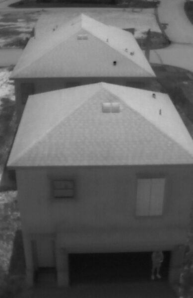
Aerial Aspectz provides drone thermal roof inspections services for buildings across Florida. We offer visual access to areas that are hard to reach by other methods.
We capture clear videos and photos of roofs and structures so you can review conditions without extra crews or equipment. Infrared imaging helps detect heating and cooling issues.
What is a Drone Thermal Roof Inspection?
A thermal drone inspection uses a radiometric thermal camera to detect heat changes across your roof. These differences help uncover issues that may not show up during a visual check. By comparing surface temperatures, you can spot signs of moisture, insulation failure, or hidden damage.
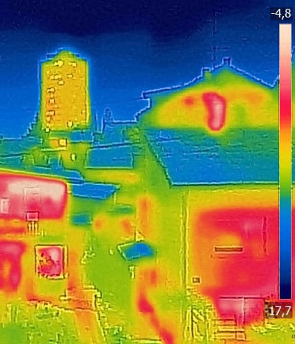
In warm months, wet insulation detection is especially useful. When part of your roof holds water, it stores heat longer than dry areas. As the surface cools in the evening, those wet zones release heat more slowly. This creates visible hotspots during an infrared roof inspection.
In colder seasons, heat escaping from your building becomes easier to see. Thermal imaging for roofs reveals problem areas by showing where energy loss occurs. Following ASTM C1153 compliance guidelines, this method can also expose gaps in insulation or early signs of failure, even when no water is present.
With drone-based thermography, you get fast, safe, and accurate data. This allows you to plan repairs, reduce building envelope energy loss, and improve the safety of your property with a drone safety inspection.
WHEN ARE DRONE THERMAL ROOF INSPECTIONS NEEDED THE MOST?
Post-Storm Damage
Identifying Moisture and Leaks
For Insurance Requirements
Why conduct a drone thermal roof Inspection
You’ve likely heard of thermal imaging for roofs, but today’s tools make it far more effective. Since ASTM C1153 compliance began in 1990, roof inspections have improved with new technology. A thermal drone inspection gives you faster results and helps spot problems early—without climbing on the roof.
With infrared roof inspection, you can catch roof leak detection issues before they become costly. Drones help identify wet spots or damaged areas so you can take action before serious repairs are needed.
You can also use drones to confirm that your roof system was installed correctly. When paired with a construction expert, drone-based thermography helps confirm that the work meets your contract. It also gives you a clear record for future reference.
Drones make inspections faster and easier. Through an aerial roof survey, one drone flight can check a large commercial roof in a short time. That saves you money and reduces interruptions at your property.
Using drones also helps reduce risk. A drone safety inspection keeps your team on the ground, cutting the chance of falls or injuries. That adds another layer of protection for your workers and your budget.
You can also include drone data in your building envelope energy loss review. This helps you find areas where energy escapes and lets you plan how to reduce waste and lower your utility bills.
How does Aerial Aspectz conduct a thermal roof inspection?
At Aerial Aspectz, we carry out every drone thermal roof inspection in line with RPAS rules and our flight safety procedures. We follow clear steps to make sure each mission stays safe and controlled.
Our inspection method follows the aerial guidelines under ASTM C1153 compliance, which sets the standard for spotting wet insulation with infrared roof inspection. While some roof types may limit results, we use tested methods to give you clear, useful data.
We start with a daytime aerial roof survey, where we capture both RGB and thermal images. As required by ASTM C1153, we complete a second scan within 48 hours. This step helps confirm temperature changes under stable conditions.
Once we collect the images, our team reviews the results. We look for signs of roof leak detection, insulation gaps, and other heat-related problems.
You’ll get a full inspection report in 14 days or less. We include both image sets and raw files so you have everything for your records.
If needed, we can refer you to engineering experts. They can help confirm findings from the drone-based thermography and guide your next steps.
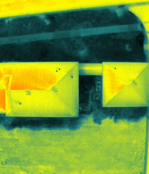
How Thermal Imaging Detects Roof Leaks in Summer
Picture a summer day when you use a drone thermal roof inspection to check a commercial flat roof. Daytime highs reach 88°F (31°C) and fall to 70°F (21°C) at night. These conditions help you find moisture trapped in roofing material. Wet areas stay warm longer than dry ones.
Now, imagine an 8-square-foot area where the gravel looks disturbed. It might not stand out in a visual check. But thermal imaging for roofs shows this section holds heat longer than nearby areas. One radiometric thermal camera reading shows it’s about 6°F (3.3°C) warmer, even hours after sunset.
This heat pattern, confirmed through an infrared drone roof inspection, points to wet insulation or a possible leak. In summer, these areas heat up fast and cool down slowly. That contrast makes them easy to spot.
This case shows why thermal image leak detection in roofs matters. It finds hidden damage that can lead to major repairs if ignored. It also helps reduce building envelope energy loss, which can raise your cooling costs.
With drone-based thermography, you get early insights. This helps you plan repairs, improve insulation, and cut down on future roof problems. It’s a smart way to keep your building in shape and avoid extra costs later.
This innovative approach to inspections is invaluable for certified home inspectors, property owners, and managers. Enabling them to evaluate the condition of properties with precision and efficiency.
Aerial Aspectz services are custom tailored to meet those specific needs.
Our goal is to empower property stakeholders by delivering comprehensive and actionable aerial data, enabling them to make well-informed decisions and proactively address potential issues.
Contact us now for more information.